


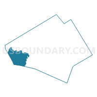
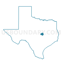
Voting District 0402, Bell County, Texas
About
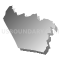
Outline

Summary
| Unique Area Identifier | 670312 |
| Name | Voting District 0402 |
| County | Bell County |
| State | Texas |
| Area (square miles) | 75.16 |
| Land Area (square miles) | 74.61 |
| Water Area (square miles) | 0.56 |
| % of Land Area | 99.26 |
| % of Water Area | 0.74 |
| Latitude of the Internal Point | 30.96405240 |
| Longtitude of the Internal Point | -97.78451330 |
Maps

Graphs
Select a template below for downloading or customizing gragh for Voting District 0402, Bell County, Texas


Neighbors
Neighoring Voting District (by Name) Neighboring Voting District on the Map
- Voting District 0015, Burnet County, TX
- Voting District 0016, Burnet County, TX
- Voting District 0203, Bell County, TX
- Voting District 0210, Bell County, TX
- Voting District 0310, Williamson County, TX
- Voting District 0401, Bell County, TX
- Voting District 0407, Bell County, TX
- Voting District 0409, Bell County, TX
Top 10 Neighboring County Subdivision (by Population) Neighboring County Subdivision on the Map
- Fort Hood CCD, Bell County, TX (15,596)
- Florence CCD, Williamson County, TX (14,845)
- South Bell CCD, Bell County, TX (9,109)
- Southwest Bell CCD, Bell County, TX (6,966)
- Briggs CCD, Burnet County, TX (1,988)
Top 10 Neighboring Place (by Population) Neighboring Place on the Map
Top 10 Neighboring Unified School District (by Population) Neighboring Unified School District on the Map
- Killeen Independent School District, TX (192,817)
- Copperas Cove Independent School District, TX (38,338)
- Burnet Consolidated Independent School District, TX (22,039)
- Lampasas Independent School District, TX (19,241)
- Salado Independent School District, TX (7,270)
- Florence Independent School District, TX (5,214)
Top 10 Neighboring State Legislative District Lower Chamber (by Population) Neighboring State Legislative District Lower Chamber on the Map
- State House District 20, TX (228,091)
- State House District 54, TX (196,447)
- State House District 55, TX (176,215)
Top 10 Neighboring State Legislative District Upper Chamber (by Population) Neighboring State Legislative District Upper Chamber on the Map
Top 10 Neighboring 111th Congressional District (by Population) Neighboring 111th Congressional District on the Map
Top 10 Neighboring Census Tract (by Population) Neighboring Census Tract on the Map
- Census Tract 233, Bell County, TX (6,966)
- Census Tract 9601, Burnet County, TX (5,731)
- Census Tract 202.04, Williamson County, TX (5,116)
- Census Tract 234.04, Bell County, TX (3,709)
- Census Tract 202.01, Williamson County, TX (1,749)
- Census Tract 9800.01, Bell County, TX (319)